


Africa News
AWS high tech casts a Halo over landmines
AI, machine learning and cloud computing is helping clear minefields, from Angola to Ukraine, writes ARTHUR GOLDSTUCK.
From the cities of Angola to the villages of Ukraine, a race against time is under way to protect civilians from a deadly, hidden peril.
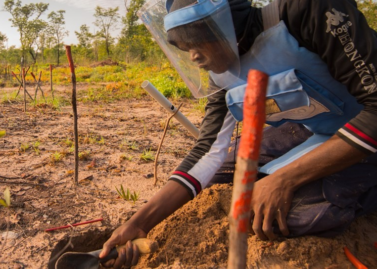
Even when the peace treaties have been signed and soldiers have gone home , the populations of war-torn countries remain in fear as roads, paths and trails are littered with landmines. An organisation called the HALO Trust (for Hazardous Area Life-support Organisation) has spent the past three decades working to clear landmines from both former and current war zones, in one of the most hazardous humanitarian tasks in the world.
But now, its work is about to become a lot easier, or at least quicker. Technology is being roped in to streamline and speed up the task of identifying landmines, munitions and other explosive ordnance left behind by war.
Last week, HALO announced that it will pilot artificial intelligence and machine learning to aid its work in Ukraine as part of a new US$4-million package of support from Amazon Web Services (AWS).
The AWS investment will assist in the process of detecting debris of war in drone imagery for existing minefields and battlefields. It will also help automate the analysis of satellite imagery to detect buildings damaged by explosives and signs of human activity near battlegrounds and minefields. That, in turn, will allow HALO to prioritise areas for clearance.
Susanna Smale, HALO regional director for Africa, told Business Times this week that the organisation remained active in Southern Africa, despite war having ended a long time ago. And the technology could transform its work here too.

Susanna Smale, Africa regional director of the HALO Trust.
“We work in over 30 territories and countries. In Africa, our work has been focused on the Horn of Africa and Angola, Mozambique, and Zimbabwe. Since starting in those programmes, some as early as 1994, for example when we started our work in Angola, we’ve had some huge success. Unfortunately, the work has been so substantial that our work continues in these countries.
“We have cleared over 170,000 land mines in Mozambique alone, and we were able to declare that country mine-impact-free in 2015. That is one of our great achievements. We have also been working in Zimbabwe since 2013, a much smaller amount of time, but due to the nature of the very dense minefields that we clear there, we’ve already cleared over 200,000 landlines, which is quite staggering.”
Halo has been working in Angola since before the end of the civil war there in 2002. When the war ended, every single one of 18 provinces was contaminated with minefields, says Smale.
“It’s a huge legacy of those wars. To date we have already cleared over 100,000 landmines in Angola and, with other explosive ordinance, over 170,000 items. Our work has been a combination of working diligently to clear those minefields for safe release back to local communities, and then conducting work around weapons and ammunition management.”
It is difficult to imagine a more hazardous working environment. But it is even more difficult for those living in such areas.
A big part of HALO’s work is risk education, teaching families living near explosive threats how to identify hazards. It uses a variety of digital and in-person methods to helps people, especially children, learn to stay safe around explosives until they can be removed for good.
“Safety is our first priority,” says Smale. “We work very diligently with standard operating procedures, in line with national standards and international standards, to ensure our people remain safe in the workplace. But one of the greatest challenges is that the challenges are different in every single place that you work.
“It’s all very context specific. The type of minefields, the way minefields have been laid, then informs how they will need to be cleared. That can be different within one country, within one province even, as well as being drastically different between different countries.”
Southern Africa stands out for the density of minefields. In Angola, a minefield can be as long as 18 kilometers long.
“And that’s just one individual minefield. We also have a large variety of landmines that we clear, and there are so many different types, different sizes, different metal content, which makes our work more challenging.
“In Angola, for example, a huge number of anti-vehicle mines have been laid along the roads. So you have that challenge of safely getting to minefields as well as the clearance of minefields themselves. Access is a huge challenge. We’re often working in rural areas in border lands, or in very rural parts of the country.”
In Angola, we’ve been successful in clearing Huambo province, but now we’re working in the rural parts of the far southeast of Angola, where you’ve got limited infrastructure, and so limited road access to places, and very challenging, sandy terrain. And time has passed since these minefields were laid, so the terrain may change, the environment may change, vegetation grows, and roads and tracks that used to be easily recognisable are no longer visible.”
In such cases, she says, advanced technology is coming to the rescue.
“One of the great things around AWS’s generous investment with us is that we can transform the way that we work in our survey process. We often don’t have maps of minefields, and that’s obviously hugely challenging. You’re working with all the evidence that you can collect in the field, be that information that local members of the community provide, or records of car accidents as a result of anti-vehicle mines.
“The process of survey work is a bit like a jigsaw, and we’ve got our colleagues out there piecing together this information, to be able to map and identify where minefields are. And that can take a very long time and that information can change over time. Some of the machine learning that we’re looking at, to combine with our drone imagery and data collection, will give us an edge to be able to identify things more quickly, which will help us with that survey piece. Critically, it means we can better target alternative assets and clearance technologies to exactly where we know those threats are.”
Dave Levy, vice president for worldwide public sector at AWS, says: “Technology, and in this case, AI specifically, has enormous potential to help solve major global challenges. We’re looking forward to working with Halo by enabling them to better harness the power of the satellite and drone imagery they are collecting to accelerate the clearing process.”
AWS is also assisting HALO in leveraging AWS cloud computing infrastructure globally and training staff to optimise its use. HALO has more than 1,200 field data collectors across 30 countries and territories who need to upload and safely store a vast quantity of data each day – from photos to spatial, and non-spatial data. Ironically, even as the volume of drone and satellite imagery grows exponentially, field workers often find themselves in areas with little or no connectivity. The challenge then is to use technology solutions that enable them to work offline and upload content to the cloud when connectivity allows.
HALO is using the AWS Cloud in several other ways:
• Running AI and Machine Learning algorithms on satellite imagery to identify damaged buildings, using its SageMaker machine learning service.
• Powering Halo’s open-source mapping project in Ukraine, which integrates open-source data from a variety of sources and brings it into a central data repository.
• Hosting Halo’s suite of business intelligence tools, which provide critical insights into Halo’s operations.
Says Smale: “The transition of our systems to the AWS cloud provides us with increased safety and security of data, including for field data collectors who upload information offline and in remote settings. Utilising those cloud systems then gives us increased safety and security of data, which is critical when you’re considering the nature of our data.”
The transformation in the ability of Halo to conduct its operations has already been dramatic.
“Historically, we’ve relied on individuals using metal detectors, and that takes a huge amount of time. You have to be extremely meticulous. Now we use different types of detection, ground penetrating radar, for example, different mechanical assets, as well as the use of satellite imagery and drone imagery. We have a whole toolbox of different technologies.”


